FAQs
What's next?
For the Internet:
We need to advocate for new advanced protocols that can take this incredible experiment to the next level. Our society deserves a better communication platform, enabling new technologies and innovations while supporting a broader future for humane networking that can massively expand the way humans share information.
For the project:
After 15 years of working with still images, we have finally produced a video. Next, we will be experimenting with newly developed 3D libraries to create an interactive version.
We are also looking for routing table snapshots before 1997 to get a complete picture of the NSFnet growth.
How do I appropriately attribute the image?
Barrett Lyon / The Opte Project
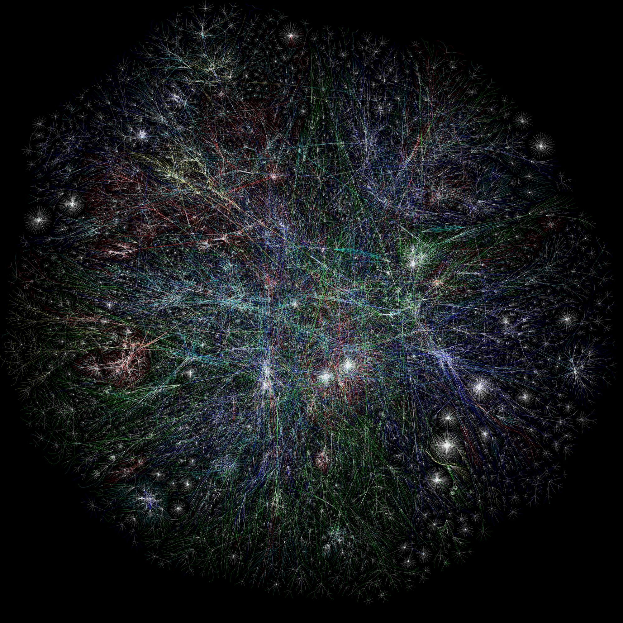
Visualization of the routing paths of the Internet.
Where are the raw images?
You can locate all of the raw images here. They’re dated and available in 10k.
What programs/code is Opte currently using?
Opte uses many different tools, scripts, and applications to generate a final image and videos. The process starts with a BGP dump from routers, which is then processed into a single image at 10k. Each image can be stand-alone or part of a video.
What does OPTE stand for?
Opte (pronounced op-tee) originated from the Latin word Opti, meaning Optical. The name originated from the project creator Barrett Lyon, and the fluidness of the name opte.org made it stick.
How the heck do you map the Internet?
The original project utilized various tracerouting mechanisms to collect route data. This was a crude attempt to gather information, but it did work. It had a number of flaws, including speed and reliability of data. The project used the smallest block that is logically routed via BGP or allocated by ARIN is a class C network (CIDR /24.) After that concept was shown as possible, I moved on to a multi-node scanning system to provide better image and route detail with the traceroute system.
Over time, it was obvious that the image needed to be based off of the Internet’s true routing table: BGP. The Border Gateway Protocolis the standard for carrier-class routing on the Internet. A single BGP feed from a provider should contain most of the routes or prefixes available at any given moment. The prefix is also accompanied by what is commonly called an “AS path”. This is the path of networks a packet must take to reach the end network based off that particular BGP feed. A single BGP feed may not include all of the paths to a specific prefix.
To ensure that this project has the most data possible, I used the data provided by the University of Oregon’s Route Views Project. Route Views has feeds from all over the Internet and allows the Opte image to be very diverse.The BGP table is then processed by several steps:
As a result, we get a very complete image that produces a very accurate view of the Internet.
How can I help the project?
Encourage your employer to use the image and buy licenses for it. In addition, we are releasing our first-ever limited edition prints which will help the project advance.
Is Opte Open Source?
We are updating and maintaining LGL which was on version 1.1, we’ve released 1.3 as open-source and currently, we are on 3.0 which has a lot of improvements including animation techniques. You can find the source code here.
Can I print these?
Simple answer: Yes if you’re not making money with it or using it for commercial purposes.
Long answer: Opte is licensed under the Creative Commons Attribution-NonCommercial 4.0 International license. This means if you use the images, you should attribute “The Opte Project / Barrett Lyon”, and if you’re using the images for commercial purposes, you should purchase a license or get written permission to use the image.
Can I use this in my book?
If the book is educational and involves research data, we typically allow the image to be used with written permission. Just send us an email about the book and we’ll get back to you.
If the image is for a commercial book, we do ask for a license which is a one-time fee. We need these licenses to fund the project.
If it's non-profit there is a license for $1.00 that can be used for the book.
What about my PowerPoint Presentation?
We offer a $1.00 license that allows for all presentations. Please see the "commercial use" tab for more information.
What is Routeviews?
University of Oregon Route Views Project
The University's Route Views project was originally conceived as a tool for Internet operators to obtain real-time BGP information about the global routing system from the perspectives of several different backbones and locations around the Internet. Although other tools handle related tasks, such as the various Looking Glass Collections (see e.g. TRACEROUTE.ORG), they typically either provide only a constrained view of the routing system (e.g., either a single provider or the route server) or they do not provide real-time access to routing data.
While the Route Views project was originally motivated by interest on the part of operators in determining how the global routing system viewed their prefixes and/or AS space, there have been many other interesting uses of this Route Views data. For example, NLANR has used Route Views data for AS path visualization and to study IPv4 address space utilization (archive).
The Internet maps created here leverage the Route Views archive data. However, the data only begins in 1997 and we are still hoping to find older routing table dumps that pre-date the Routeviews archive.
I have a BGP dump before 1997!
OMG this is great news... please contact me asap. blyon@opte.org